In our continuing effort to keep members apprised of the Mayflower Wind project:
Mayflower Wind filed a petition for Falmouth Zoning Bylaws Exemptions with the State of Massachusetts on Nov 17, 2021 with respect to the onboarding of power cables from their proposed offshore wind farm located 20 miles south of Nantucket and 30 miles south Martha’s Vineyard (FHMNA post 12/6/21 Comments Requested)
Contained in this petition is some interesting language with regard to the “Preferred Routing” of such cables. See the full petition and the map below. Also below are some paragraphs we found particularly interesting including section 17 and the section FHMNA has bold faced: “The main appeal of this location….” and “Stakeholder engagement will be critical…”
Excerpted wording as follows:
…
II. C. i. Preferred Route: Worcester Ave. + Gifford St. to Preferred Mayflower Wind Substation – Lawrence Lynch
17. The onshore portion of the Preferred Route begins at Worcester Ave Landfall which is the easternmost landfall location, situated within the first block of Worcester Park between the two lanes of Worcester Ave. The first segment of the Preferred Route (approximately 0.04 m (0.06 km)) would be installed within Worcester Park to reduce potential utility conflicts, allow for faster installation and reduce potential traffic disruptions.
Thereafter, the Preferred Route would enter the Worcester Court roadway and follow existing roadway layouts, with duct banks installed beneath or adjacent to the paved roadway.
________________________________________
Earlier, in August 2021, Mayflower also filed:
Excerpted wording as follows:
2.4.2 Alternate Landfall Location(s)
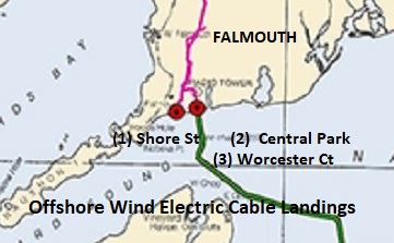
There are three landfall points being considered in the town of Falmouth (See Figure 7 in Attachment 1). These landfall locations include:
1. Shore Street at its intersection with Surf Drive (Figure 8 in Attachment 1);
2. Central Park north of Grand Street (Figure 9 in Attachment 2); and
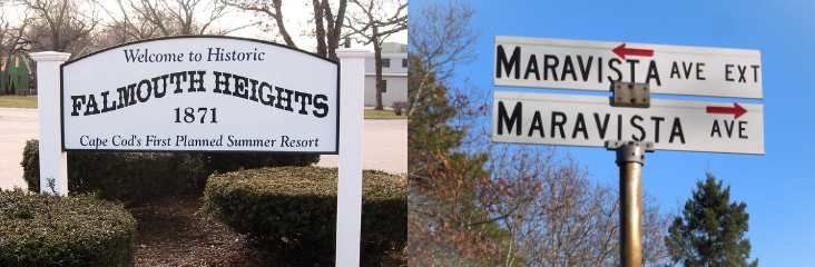
3. Worcester Avenue near its intersection with Grand Avenue (in Worcester Park) (Figure 10 in Attachment 1).
(Ed.: For a more clear map of routes, see FHMNA website post 9/27/21: “Mayflower Wind Rejects Surf Drive as a Cable Landfall Site” which includes a link to Mayflower Wind’s website where you must scroll down to “Making landfall” to see the map. Click on the map to make it bigger.
The estimated locations of sensitive coastal habitats in the nearshore areas of the three Falmouth landfall locations under consideration are shown in Figure 7. The Worcester Avenue landfall location in Falmouth, MA, near the intersection of Worcester Avenue with Grand Avenue (in Worcester Park), is the preferred landfall as the area is protected by a short seawall, a broad beach, and Grand Avenue. The main appeal of this location is the large grassy median strip, or common, that runs between the two lanes of Worcester Avenue and is surrounded by businesses and residences on either side. This area has only a slight elevation making it a prime candidate for an HDD landfall as well as being unlikely to be impacted by a typical storm event. Stakeholder engagement will be critical at this location as the area is home to a popular road race as well as hotels and inns. There are no known existing submarine cables that make landfall at Worcester Avenue and this landfall would avoid the need to cross any of the existing submarine cables between Martha’s Vineyard and Falmouth. The grassy median strip would require re-landscaping after installation but would not require re-paving or any intensive repair following the installation of the cables (see Figure 10 in Attachment 1).
Selection of the preferred landfall location(s), as well as the HDD landfall installation method, were important considerations in preventing impacts to coastal areas. All locations were evaluated for their potential effects on coastal and nearshore environments including coastal, beaches, and coastal dunes (see Figure 8 through Figure 10 in Attachment 1). Using an HDD landfall method will prevent or avoid excessive impacts to nearshore resources such as SAV and eelgrass beds that would be otherwise impacted with an open trench installation. This method will also reduce impacts to public access to coastal areas as the installation will take
place beneath the coastal beach and intertidal area at Falmouth Heights Beach.
Another factor considered in the selection of the preferred landfall location is its effect on the onshore route. The landfall point will be the beginning of the onshore transmission route in Falmouth and the preferred landfall location at the intersection of Worcester Avenue and Grand Avenue will ensure that the cable route will be able to be located within and beneath existing roadways to the substation facility. This will limit disturbances to natural areas along the Project onshore route.
2.4.3 Potential Onshore Substation Locations
The two locations being examined are in close proximity to the POI (Falmouth Tap) determined preliminarily by ISO-NE. The final location of the onshore substation will determine the ultimate lengths of the underground onshore export cables and alternate underground transmission route. The current preferred site for the onshore substation is Lawrence Lynch. This site consists predominantly of disturbed land (see Figure 3 in Attachment 1). Cape Cod Aggregates is also largely disturbed bare land with low vegetations along the margins (see Figure 3 in Attachment 1). For more information on potential substation locations, please see COP Section 3.3 – Project Components and Project Stages.